Search This Blog

Wednesday, September 30, 2015

Las Vegas 015 (Hoover Dam)

Hoover Dam tour. September 23, 2015.


#HooverDam #electricity #hydroelectric #Nevada #Arizona


Las Vegas 014 (Hoover Dam)

Turbine room on Hoover Dam tour. September 23, 2015.


#HooverDam #electricity #hydroelectric #Nevada #Arizona


Las Vegas 013 (Hoover Dam)

Tunnel in native bedrock on Hoover Dam tour. September 23, 2015.


#HooverDam #Nevada #Arizona


Las Vegas 012 (Hoover Dam)

Back in the tunnels. Tour of Hoover Dam. September 23, 2015.


#HooverDam #Nevada #Arizona


Las Vegas 011 (Hoover Dam)

Tour of Hoover Dam. September 23, 2015.


#HooverDam #Nevada #Arizona

Las Vegas 010 (Hoover Dam)

Hoover Dam tour. September 23, 2015.


#HooverDam #Arizona #Nevada

Las Vegas 009 (Hoover Dam)

Hoover Dam tour. September 23, 2015.


#HooverDam #Nevada #Arizona


Las Vegas 008 (Hoover Dam)

Passing through tunnels in native bedrock on Hoover Dam Tour. September 23, 2015.


#HooverDam

Hoover Dam

From the Bureau of Reclamation:


On September 30, 1935, President Franklin Roosevelt dedicated Hoover Dam. Learn more dam facts athttp://bit.ly/HooverDamFAQs
#Hoover #HooverDam #DamFacts#BureauofReclamation#TodayInHistory

Monday, September 28, 2015

Friday, September 18, 2015

Putin & Sarah Palin Phone Call on "Tonight Show"

This man is living proof you can take body building too far

Look at this guy's upper body and then look at his legs!


Open Data: a Key to Feeding 9 Billion People by 2050

From the #USDA:


NPR’s “The Takeaway” program recently examined the “The Biggest Challenges Facing America and the World.” The episode included an interview with USDA Chief Scientist and Undersecretary Catherine Woteki on the challenge of being able to feed a world population that is estimated to reach more than 9 billion people by the year 2050.
On behalf of USDA, Dr. Woteki played a key role in the formation of Global Open Data for Agriculture and Nutrition (GODAN), an international organization which supports efforts to make agricultural and nutritional data available, accessible, and usable for unrestricted use worldwide. She said harvesting such data could be a key to harvesting enough future crops to meet future challenges.
“One of the things that we at USDA already do is to maintain a collection of germplasms from crops and their wild relatives that we have been investigating for many years and keeping over the years as a resource for plant breeders,” Woteki said.
“As scientists have been sequencing the DNA of these various samples that are part of our collection, they’ve also been looking for some genes that convey some very valuable traits – like pest or disease resistance – or the attribute that would make this particular strain of wheat, for example, better for making bread or pastry, and identifying those specific genes and the quality traits that they convey.”
Dr. Woteki, who also discussed open data access efforts in detail in a recent Thomson-Reuters report entitled “How Will We Fill 9 Billion Bowls,” said she was optimistic about the challenges that lay ahead.
“We have a finite amount of farmable land, and some of that already is severely degraded,” she said. “The UN estimates that about a quarter of arable land is currently severely degraded. And we are very much aware of limits on water availability for agriculture. Farmers all over the world are having to deal with more variable weather conditions that are related to climate change.”
“But in the scientific community, we think that we will be able to sustainably intensify the productivity of agriculture to be able to feed that population as projected at mid-century at over 9 billion people, and also to be able to deliver all of the other benefits that are expected from agriculture,” she said. “That includes clean water, the production of feed stocks that are going to be used for biofuels and other industrial chemicals, and doing it in a way that’s going to be sustainable into the future generations beyond the year 2050.”
    

Wildfire Smoke Monitors Working to Reduce Health and Safety Impacts

From the #USDA:


A Environmental Beta Attenuation Monitor in a forest
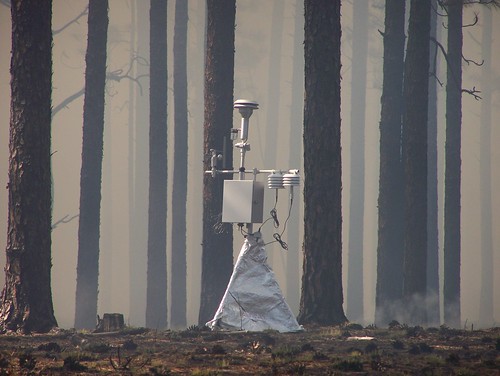
Environmental Beta Attenuation Monitors (E-BAMs) are portable particulate monitoring stations. They are one technological tool used to monitor smoke. They can transmit their data via satellite to a central location for analysis. USFS photo.
Smoke from wildfires can have an enormous impact on the public and on fire personnel, affecting health, interfering with transportation safety and upsetting tourism and local economies.
Trent Procter, like all U.S. Forest Service Air Resource Advisors, is a technical specialist with expertise in air quality science, including: air quality monitoring, smoke modeling, pollutant health thresholds and communicating about smoke risks and mitigation.
“Smoke from wildland fire is a significant source of air pollution. It can pose potential risks to health, visibility, safety and general nuisance problems. Forest managers, fire managers and air resource specialists must address these issues when and where appropriate to minimize smoke impacts to public health and welfare,” he explained.
Exposure to smoke is a concern because a large proportion of wildland fire smoke emissions are fine particulate matter that can penetrate to the deepest parts of the lungs.
Air Resource Advisors can be dispatched to an incident to assist with understanding and predicting smoke impacts on the public and on fire personnel. Whenever smoke is a concern, their objective is to provide timely smoke impact and forecast information and messages based on best-available science.
Technology plays a big part in this forecasting process. 
“Satellite images, monitoring data and smoke modeling projections all inform the typical smoke forecast,” Procter explained.
The Forest Service works with partner agencies to deploy “real time” monitoring http://app.airsis.com/usfs/fleet.aspx into communities and locations where instant feedback is helpful in keeping the public and health officials informed.  The monitors transmit the smoke concentrations to satellites and then back to web-based tools that help provide the smoke concentrations seen in the forecasts. 
Air Resource Advisors work with multiple agencies to address public health concerns, smoke risk to transportation safety and fire personnel exposure, as well as how to reduce and mitigate smoke exposure.
As the Pacific Southwest Region’s Air Quality Manager, Procter’s work takes him throughout the state, and during this year’s drought-fueled wildfire season, he’s been busy coordinating with other agencies for appropriate response to smoke.
“The success in bringing helpful information to the public in California is a credit to our partners at the air pollution control districts and the California Air Resources Board.  The staffs in these agencies are professional and so very dedicated to an emergency response that helps the public reduce or manage their exposure,” he said.
Before igniting a prescribed fire – a fire being used for specific land management objectives – managers must identify smoke-sensitive areas such as communities, hospitals and highways and use appropriate mitigation and evaluation techniques to minimize smoke impacts. Weather, climate and air quality monitoring data are used by fire managers to customize smoke management techniques as needed in these cases.
“In the case of wildfires, where managers have little or no control over what burns, many times it’s a matter of understanding fire behavior, fuel combustion and suppression techniques,” Procter explained.
“That enables us to understand how those features and management actions will play out with weather forecasts and subsequently allow a credible forecast of where smoke will go — or sometimes, more importantly, where it won’t go.  Our recent efforts to improve wildfire smoke forecasting are allowing us to learn much that can improve our smoke management techniques in prescribed fire projects.”
A pyrocumulus cloud forming over the 2015 Rough Fire
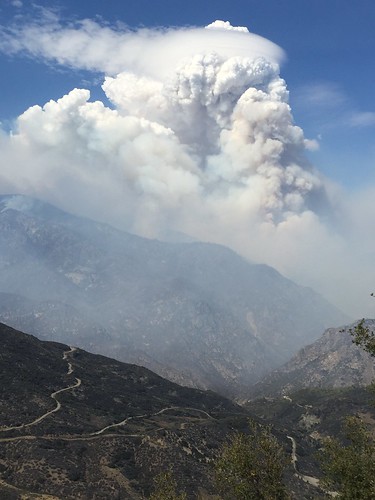
A pyrocumulus cloud produced by the intense heating of the air from the surface forms over the 2015 Rough Fire. Wildfires can create their own weather patterns which can complicate the job of Air Resource Advisors. USFS photo.
    

Thursday, September 17, 2015

Do YOU Have a Plan for Your Pets Should a Hurricane Strike?

From the #USDA:


August marked the 10th anniversary of Hurricane Katrina.   The powerful storm had a devastating impact on the people, the culture and the pets of the Gulf Coast states. According to The Humane Society of the United States, more than 6,000 pets were rescued during Katrina, and responders and volunteers spent months tracking lost pets and reuniting them with their owners. Some never were.  The destruction of Katrina was like no other hurricane the United States had seen before; however, hurricanes will always be a threat. Preparing for future hurricanes will determine how much impact another storm will have on our lives and the lives of our pets.
And because September is National Preparedness Month, USDA’s Animal and Plant Health Inspection Service (APHIS) wants to remind you of the importance of having a plan in place for both you and your pets in the event of a hurricane. If you have to evacuate your home, do not leave your pets behind. They will mostly likely not survive if left on their own and you might not be able to find them again if you do.
Some public shelters do not welcome pets and you need to plan for alternative safe havens for your pets, such as a friend’s house outside of the impacted area.  Additionally, consider developing the buddy system with neighbors, friends and relatives to help evacuate your pet if you cannot do it yourself.
Additionally, contact your local emergency management agency for specific information about your area before disaster strikes.  Your local emergency management agency also will have critical information about local resources, such as where you can evacuate with your pet.  These few simple steps provided by the Federal Emergency Management Agency (FEMA) will help you prepare for your pet’s safety during a hurricane.  And your local emergency management organization can help you with the points marked below with a * star.
1. PREPARE a pet emergency supply kit
  • Three day supply of food and water *
  • Copy of medical and vaccination records in a waterproof container
  • Extra supply of medications your pet is currently taking
  • Extra leashes, collars and ID tags
  • A sturdy, safe and comfortable crate/carrier should you need to evacuate with your pet *
  • Paper towels, plastic bags and disinfectant for waste clean-up
  • A picture of you and your pet should you get separated
  • Familiar items such as favorite toys, treats and bedding
2. PLAN what you will do in an emergency
  • If you must evacuate, take your pets with you, if practical
  • Secure your destination ahead of time *
  • Plan with your neighbors, friends or relatives to ensure someone can care for your pets in the event you are unable to do so
  • Get the names of veterinarians or veterinary hospitals in other cities you are likely to seek temporary shelter *
  • Make a list of contact information and addresses of area animal control agencies including the Humane Society, or SPCA, and emergency veterinary hospitals *
3. STAY INFORMED know about types of emergencies
  • Know the types of emergencies that are most likely to occur in your area *
  • Know what emergency plans have been established by your state and local government *
While we hope a disaster never strikes, careful preparation for your family and pets, can help alleviate even the worst results of a disaster.   To learn more about APHIS’ role in the national plan, visit www.aphis.usda.gov, or visit FEMA’s website at http://www.ready.gov/sites/default/files/documents/files/pets_brochure.pdf.
    

A Special Invitation from Deputy Secretary to Join a Google+ Hangout on Veteran Farmers

From the #USDA:


A man holding plant seedlings with the USA flag behind him
Helping our Returning Heroes find Opportunities in Agriculture: Join us for a Google+ Hangout with Agriculture Deputy Secretary Krysta Harden. Tune in live on Thursday, September 17, 11AM ET at www.usda.gov/live
On Monday, I had the opportunity to meet with several inspiring Service members and launch an expanded collaboration between USDA and the Department of Defense at a Transition Assistance Program class hosted at the Pentagon. This collaboration will integrate agriculture into the career training and counseling programs Service members receive as they transition out of the military. Information about USDA resources and programs will now reach 200,000 transitioning Service members every year.
It’s exciting to see veterans — many of whom come from rural communities — drawn back to the land, and USDA is here to provide support for military veterans and their families, from nutrition assistance to rural rental housing and homeownership opportunities. In conjunction with Monday’s announcement, USDA also launched a new website, www.usda.gov/veterans. This site is specifically designed to educate veterans about USDA programs and the support available for all active duty military and veterans.
Let’s keep the conversation going! Join me at 11 a.m. Eastern on September 17 for a Google+ Hangout, which will feature veteran farmers and veteran training organizations who will provide insight into challenges and opportunities in farming and ranching. Ask questions of the panelists by leaving them in the comments section below or by using #NextGenAg on Twitter. Be sure to RSVP to attend the event on our Google+ page and tune in live on Thursday by visiting the USDA Google+ page or www.usda.gov/live. We can’t wait to hear from you!
    

No Books Required for Back-to-School Night at USDA Farmers Market on Friday, September 18

From the #USDA:


USDA Farmers Market at Night Back-to-School Night poster
Join us for Back to School Night at the USDA Farmers Market in Washington, D.C., on Friday, Sept. 18, 2015. (Tip: you can print and color this market poster. Click to enlarge)
It’s “Back-to-School Night” at the USDA Farmers Market on Friday, September 18, from 5 p.m. to 8 p.m., in Washington, D.C., near the National Mall.  This month’s educational exhibitors and vendors will appeal to students of any age.  Market visitors can learn more about healthy eating, reducing food waste or take a trip down memory lane and eat a snack or meal off a planet-friendly disposable lunch tray!
Members of USDA’s Team Nutrition will be at the market to explain how to eat healthy in and out of school. Executive Chef Adam Tanner, from the Mandarin Oriental Washington, DC, will show you how to cook delicious and nutritious snacks.
In the United States, food waste, including uneaten food from school cafeterias, is estimated at between 30-40 percent of the food supply.  College student volunteers from the Food Recovery Network (FRN) will use games to teach facts about food waste and hunger in America. College students can step up to the challenge to reduce food waste by recovering perishable food that would otherwise go to waste from their campuses and communities and donate it to people in need.  FRN also will recover food at the end of the September 18 market. 
You also can meet the student run board of Georgetown University Farmers Market who will share their story. The on-campus market was founded to improve access and availability of healthy, fresh food on Georgetown’s campus located in the District of Columbia’s Ward 2–the ward as the USDA Farmers Market.
And volunteers from USDA’s People’s Garden Initiative will give out school gardening tips and insect collection kits.
You won’t want to miss the members of Union Kitchen, a Washington, D.C.-based food incubator, who will offer foods on planet-friendly disposable lunch trays. DMV Food Truck Association vendors including Captain Cookie & The Milkman, The Big Cheese, Fava Pot, Hardy’s BBQ, Sang on Wheels and KaftaMania will be there, too.
This month’s live entertainment will feature a high energy 6-piece indy rock band called The North Country.
We hope to see you on Friday, September 18, if you are in the DC area.  If you can’t join us, check for a farmers market in your hometown or wherever you travel by visiting USDA’s Local Food Directories.  The directories are an easy, one-stop shop for information on local farmers markets, community-supported agriculture (CSA) enterprises, food hubs, and on-farm markets.  All of these initiatives contribute to USDA’s Know Your Farmer, Know Your Food(KYF2) initiative, which coordinates efforts across USDA to support local and regional food systems. 
USDA’s Agricultural Marketing Service (AMS) has managed the weekly daytime USDA Farmers Market, at 12th and Independence Avenue, S.W., in Washington, D.C. for 20 years.  The daytime market is open on Fridays from 9 a.m. to 2 p.m., May through October.
This year, the USDA Farmers Market team is experimenting with a series of six monthly USDA Farmers Market at Night.  Each night market, open from 5 p.m. to 8 p.m. on the third Friday of the month from May through October, will feature different vendors than those at the day market as well as different live entertainment and educational exhibits.
For more details, follow us on Twitter @USDA_AMS.  Look for the #USDAFarmersMkt hashtag for updates about both the day and night markets or visit us online.
    

Blue Ridge Parkway

From U.S. Department of the Interior:


Magnificent #SunriseThisMorning at Blue Ridge Parkway. This stunning photo was taken by Eric Allen Van Tassel at the East Fork Overlook on North Carolina side of the Parkway. Feeling lucky to stumble upon the overlook at the right time, Eric is still hesitant to show it off because “I felt the product does not reflect the overwhelming beauty and the excitement we experienced watching the sunrise that morning.” We know the feeling, but think this photo is definitely worth sharing! Photo courtesy of Eric Allen Van Tassel.

Want to be featured on Interior’s account? We’re partnering with CBS This Morning to share amazing sunrise photo from America’s national parks and other public lands. Tag your photos with #SunriseThisMorning for a chance to have one of your photos appear on our feeds!


Wednesday, September 16, 2015

Mobile User Objective System (MUOS) communications satellite

From the U.S. Department of Defense (DOD):


The U.S. Navy's fourth Mobile User Objective System (MUOS) communications satellite, was launched from Cape Canaveral, Florida on September 2. The MUOS is encapsulated in a 5-meter payload fairing and is a next-generation narrow band tactical satellite communications system designed to significantly improve beyond-line-of-sight communications for U.S. forces on the move. 

Photo courtesy United Launch Alliance

Storms A-Brewin'

From NOAA Satellite and Information Service:


On the morning of September 16, 2015, the NOAA NOAA NWS National Hurricane Center notes that showers and thunderstorms in the Atlantic have continued to become better organized during the past few hours. The showers and thunderstorms are associated with a low pressure system located about midway between the Cape Verde Islands and the Lesser Antilles. If these trends continue, a tropical depression could form later this morning before upper-level winds become less conducive for development by tomorrow.

A broad area of low pressure located about 350 miles southwest of the southernmost Cape Verde Islands continues to produce disorganized shower activity. Environmental conditions are expected to be conducive for the formation of a tropical depression over the next few days while the system moves west-northwestward at 10 to 15 mph. For the full and updated official forecast, see http://www.nhc.noaa.gov/?atlc.

This Suomi NPP VIIRS image was captured on the evening of September 15, 2015. (www.nesdis.noaa.gov)


Our Shrinking Moon

From #NASA:


The moon is shrinking. Tidal forces combined with the shrinking of the moon from cooling of its interior have created a network of young fault cliffs. These faults have emerged as the most common tectonic landform on the moon. Find out more:http://go.nasa.gov/1NxYcqX #NASABeyond

“See Mankind in Space Through Slooh”

From NASA:


“See Mankind in Space Through Slooh” - Today is at the halfway point of NASA Astronaut Scott Kelly's historic #YearInSpace mission on the International Space Station. Slooh will hold a special show at 12 a.m. (midnight) EDT to mark this space milestone and broadcast live the station as it passes overhead. Watch: http://www.nasa.gov/nasatv

Tuesday, September 15, 2015

Prepare to Expect the Unexpected

From the #USDA:


It’s hurricane season again.  It’s hard to believe that it was just 10 years ago when Hurricane Katrina devastated New Orleans and a large portion of the Gulf Coast with floods, power outages, food and water shortages, as well as many other after effects.
September is National Preparedness Month, which is a great opportunity for you, organizations, and communities to prepare for specific hazards through drills, group discussions, and exercises.  The focus this year is making sure that you and your community are prepared for six specific hazards: earthquake, flood, hurricane, tornado, wildfire and winter storm.
To help you, USDA recommends the Extension Disaster Education Network (EDEN) as your one-stop shop for information on how to prepare for and respond to disasters.  It is a collaborative multistate effort by extension services across the country to improve the delivery of services to citizens affected by disasters.  EDEN is hosted by the Louisiana State University Ag Center and funded by the U.S. Department of Agriculture’s National Institute of Food and Agriculture (NIFA). 
Preparedness goes beyond the home, so you also need to consider what to do if disaster strikes while you, a loved one or friend is at work.  The Federal Emergency Management Agency (FEMA) recommends that workers put together emergency plans and a “grab-and-go” bag in case they are required to “hunker down” or stay in offices/buildings/schools/businesses for up to three days. FEMA recommends that these bags include clothing, flashlights, toiletries, battery radio, canned food, and whatever else one might needed during an emergency.  Do you have a “grab-and-go” bag?
If you already have a grab-and-go bag, great!  Is it up-to-date?  Are the batteries still good?  Are you brave enough to eat the food you packed without checking first to see if it’s past the expiration date? Because most disasters cannot be predicted; you must remain vigilant with routine preparations for any possible situation.
The following list might help you get started as you prepare your plan and “grab-and-go” kit:
  • Be Informed – Learn what protective measures to take, before, during, and after an emergency.
  • Make a Plan – Prepare, plan, and stay informed for emergencies.
  • Build a Kit – Build a kit for disasters to be prepared.
  • Get Involved – Find opportunities to support community preparedness.
  • Protect Your Business – Plan for and protect your business.
  • Kids – Fun and games for kids. Great tools for educators and parents.
Are you prepared for the unexpected? 
NIFA invests in and advances agricultural research, education, and extension and seeks to make transformative discoveries that solve societal challenges.
    

Great Falls Park

September 15, 2015

From the U.S. Department of the Interior:


Just before it flows past Washington, DC, the Potomac River builds up speed and force as it falls over a series of steep, jagged rocks and rushes through a narrow gorge. Great Falls Park offers tremendous views of this powerful, natural spectacle. Hikers enjoy several trails along the river and sometimes gasp at expert kayakers who brave the falls. This #sunrise picture was taken on the Virginia side of the river. Photo by Yin Lau. (www.sharetheexperience.org) — at Great Falls Park.