Saturday, April 30, 2016
Little Colorado River
April 30, 2016
From the Bureau of Reclamation:

The photo of the day is the Little Colorado River, a tributary of the Colorado River in Arizona. Reclamation photo by Andy Pernick. #scenic
From the Bureau of Reclamation:

The photo of the day is the Little Colorado River, a tributary of the Colorado River in Arizona. Reclamation photo by Andy Pernick. #scenic
Friday, April 29, 2016
Happy #FullDiskFriday!
From NOAA Satellite and Information Service:

Happy #FullDiskFriday! As we head into the weekend, we want to take a moment to step back, 22,240 miles to be exact, and appreciate our amazing planet.
Each Friday we feature one of the many full disk Earth images captured by environmental satellites. This week, our image comes to us from the Japan Meteorological Agency's Himawari-8 satellite. This water vapor image, which was taken today, April 29, 2016, at 2:00pm EDT, shows the moisture content in the atmosphere over the entire Eastern Hemisphere. The bright and colored areas indicate high water vapor (moisture) content and/or ice crystals, while black and brown areas indicate little or no moisture present. Water vapor imagery is useful for both determining locations of moisture and atmospheric circulations.
The Himawari-8 satellite is the first unit of the Japan Meteorological Agency's third generation of geostationary satellites. The satellite provides visible light and infrared images of the Asia-Pacific region and its data are vital for global geostationary coverage. What's more, because it carries similar advanced imagers, Himawari-8 gives us a preview of what we can expect from NOAA's GOES-R satellite after it launches later this year.
To see more real-time full disk imagery, visithttp://go.usa.gov/cu5jk
What is a "SPENES" message and what does it look like?
From NOAA Satellite and Information Service:

What is a "SPENES" message and what does it look like?
The answer lies with the NOAA NESDIS's Satellite Analysis Branch (or SAB), which routinely provides analyses of satellite-derived weather data and trends to the National Weather Service's Weather Prediction Center (WPC) for use in the WPC's Mesoscale Precipitation Discussions (MPDs).
MPDs provides short-term guidance to National Weather Service forecast offices during heavy rain events that may lead to flash flooding. Ideally issued 1-6 hours ahead of time, MPDs consist of a graphic indicating the area of concern and any pertinent meteorological features, as well as a brief text discussion focused on the mesoscale features supporting the anticipated heavy rainfall.
In addition, the SAB provides satellite-based guidance messages, or SPENES, to the NWS Field Offices in Hawaii and Puerto Rico when heavy rains threaten those areas.
So, what does a SPENES message look like? Check out the links below for active messages or view older ones in the archives that date back to 2007.
Active Messages: http://go.usa.gov/cu9ux
Archived Messages: http://go.usa.gov/cu9ze
Another Quiet Day in the Tropics!
From NASA's Hurricane Web Page:
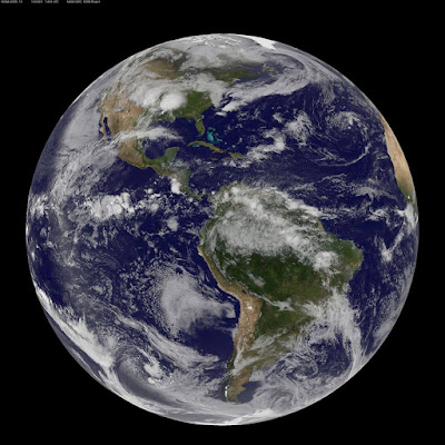
Another Quiet Day in the Tropics!
Around the world, the tropics are quiet today, Friday, April 29, 2016. There are no areas suspect for tropical cyclone development. This view of the Atlantic and Eastern Pacific Oceans was created using images from NOAA's GOES-East satellite today.

Another Quiet Day in the Tropics!
Around the world, the tropics are quiet today, Friday, April 29, 2016. There are no areas suspect for tropical cyclone development. This view of the Atlantic and Eastern Pacific Oceans was created using images from NOAA's GOES-East satellite today.
Let's Get Jazzed 022

Paul Eade painting sold at auction, Let's Get Jazzed fundraiser for Newhouse Shelter, Kansas City, Missouri. April 28, 2016.
#letsgetjazzed #kansascity
#JonKraft
Let's Get Jazzed 021

Finished Paul Eade painting sold at auction, Let's Get Jazzed fundraiser for Newhouse Shelter, Kansas City, Missouri. April 28, 2016.
#letsgetjazzed #kansascity
#JonKraft
Let's Get Jazzed 020

Dessert bar, Let's Get Jazzed fundraiser for Newhouse Shelter, Kansas City, Missouri. April 28, 2016.
#letsgetjazzed #kansascity
#JonKraft
Let's Get Jazzed 019

Bananas Foster, Let's Get Jazzed fundraiser for Newhouse Shelter, Kansas City, Missouri. April 28, 2016.
#letsgetjazzed #kansascity
#JonKraft
Let's Get Jazzed 018

Vanilla and strawberry ice cream, Let's Get Jazzed fundraiser for Newhouse Shelter, Kansas City, Missouri. April 28, 2016.
#letsgetjazzed #kansascity
#JonKraft
Let's Get Jazzed 017

Bananas Foster Cake with Caramel sauce, Let's Get Jazzed fundraiser for Newhouse Shelter, Kansas City, Missouri. April 28, 2016.
#letsgetjazzed #kansascity
#JonKraft
Let's Get Jazzed 016

Angel Food Cake with strawberry sauce, Let's Get Jazzed fundraiser for Newhouse Shelter, Kansas City, Missouri. April 28, 2016.
#letsgetjazzed #kansascity
#JonKraft
Let's Get Jazzed 015

Caramel brownie with chocolate sauce, Let's Get Jazzed fundraiser for Newhouse Shelter, Kansas City, Missouri. April 28, 2016.
#letsgetjazzed #kansascity
#JonKraft
Let's Get Jazzed 014

Smoked beef brisket, Let's Get Jazzed fundraiser for Newhouse Shelter, Kansas City, Missouri. April 28, 2016.
#letsgetjazzed
#JonKraft
Let's Get Jazzed 013

Smoked BBQ chicken, Let's Get Jazzed fundraiser for Newhouse Shelter, Kansas City, Missouri. April 28, 2016.
#letsgetjazzed
#JonKraft
Let's Get Jazzed 012

BBQ baked beans, Let's Get Jazzed fundraiser for Newhouse Shelter, Kansas City, Missouri. April 28, 2016.
#letsgetjazzed
#JonKraft
Let's Get Jazzed 011

Cheddar mashed potatoes, Let's Get Jazzed fundraiser for Newhouse Shelter, Kansas City, Missouri. April 28, 2016.
#letsgetjazzed
#JonKraft
Let's Get Jazzed 010

Cole slaw, Let's Get Jazzed fundraiser for Newhouse Shelter, Kansas City, Missouri. April 28, 2016.
#letsgetjazzed
#JonKraft
Let's Get Jazzed 009

The salad, Let's Get Jazzed fundraiser for Newhouse Shelter, Kansas City, Missouri. April 28, 2016.
#JonKraft
Let's Get Jazzed 008

Lonnie McFadden jazz band playing at the Let's Get Jazzed fundraiser for Newhouse Shelter, Kansas City, Missouri. April 28, 2016.
#JonKraft
Thursday, April 28, 2016
Let's Get Jazzed 007

Paul Eade paintings being painted for auction later tonight. Let's Get Jazzed fundraiser for Newhouse Shelter, Kansas City, Missouri. April 28, 2016.
#JonKraft
Let's Get Jazzed 006

Lonnie McFadden warming up. Let's Get Jazzed fundraiser for Newhouse Shelter, Kansas City, Missouri. April 28, 2016.
#JonKraft
Let's Get Jazzed 005

Paul Eade painting at Let's Get Jazzed fundraiser for Newhouse Shelter, Kansas City, Missouri. April 28, 2016.
#JonKraft
Let's Get Jazzed 004

He's so sleepy! Let's Get Jazzed fundraiser for Newhouse Shelter, Kansas City, Missouri. April 28, 2016.
#JonKraft
Let's Get Jazzed 003

Silent auction items. Let's Get Jazzed fundraiser for Newhouse Shelter, Kansas City, Missouri. April 28, 2016.
#JonKraft

Let's Get Jazzed 001

Statue of Lamar Hunt at Arrowhead Stadium, Kansas City, Missouri. Location of Let's Get Jazzed fundraiser for Newhouse Shelter, Kansas City, Missouri. April 28, 2016.
No Safe Place When Thunderstorms Nearby
April 28, 2016
From the U.S. National Weather Service (NWS):

There is no safe place outside when thunderstorms are in the area. If you hear thunder, you are likely within striking distance of the storm. Just remember, When Thunder Roars, Go Indoors.http://
From the U.S. National Weather Service (NWS):

There is no safe place outside when thunderstorms are in the area. If you hear thunder, you are likely within striking distance of the storm. Just remember, When Thunder Roars, Go Indoors.http://

Second Round of Intense Storms Bringing Hail, Wind, Heavy Rainfall and Tornadoes to the Central United States
From NOAA Satellite and Information Service:

This image, taken yesterday (4/27) by the GOES-East satellite, shows the second round of intense storms to bring hail, wind, heavy rainfall and tornadoes to the Central United States. Since Tuesday, the system has spurred more than a dozen confirmed tornadoes as well as 270 reports of wind damage and at least 240 reports of hail.
For the most recent weather forecast and information, please visit www.weather.gov.
Image courtesy of NOAA's Environmental Visualization Laboratory (http://go.usa.gov/cukvJ)
Weather Forecast for April 28, 2016
From the U.S. National Weather Service (NWS):
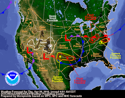

Severe thunderstorms possible over parts of the Plains & Mid-Atlantic, with heavy rain expected over portions of the Plains and lower Mississippi Valley. Snow possible in the central Rockies. http://
Wednesday, April 27, 2016
Estimating Black Carbon Reaching the Environment
From #NASA:

The amount of black carbon, or soot, that reaches the Arctic is currently poorly estimated. In addition to absorbing sunlight while aloft, which heats the air, black carbon darkens white snow when it settles on the surface, accelerating snowmelt. New scrutiny will help combine satellite observations with modeling and monitoring efforts to better understand the impacts. Details:http://go.nasa.gov/1rAzsYu

The amount of black carbon, or soot, that reaches the Arctic is currently poorly estimated. In addition to absorbing sunlight while aloft, which heats the air, black carbon darkens white snow when it settles on the surface, accelerating snowmelt. New scrutiny will help combine satellite observations with modeling and monitoring efforts to better understand the impacts. Details:http://go.nasa.gov/1rAzsYu
A stray stormcloud chases the moon above the famous hoodoos of Bryce Canyon National Park in Utah
From the U.S. Department of the Interior:

A stray stormcloud chases the moon above the famous hoodoos of Bryce Canyon National Park in Utah. Hoodoos -- also called “goblins” -- appear as tall, skinny spires of rock sticking up from the bottom of dry basins and range in size from the height of a person to as large as a 10-story building! Nowhere in the world has more hoodoos than Bryce Canyon. Photo by photobylitho from Interior’s America’s Public Lands group on Flickr. — at Bryce Canyon National Park.

A stray stormcloud chases the moon above the famous hoodoos of Bryce Canyon National Park in Utah. Hoodoos -- also called “goblins” -- appear as tall, skinny spires of rock sticking up from the bottom of dry basins and range in size from the height of a person to as large as a 10-story building! Nowhere in the world has more hoodoos than Bryce Canyon. Photo by photobylitho from Interior’s America’s Public Lands group on Flickr. — at Bryce Canyon National Park.
Our Students Have a Voice in School Meals
From the #USDA:
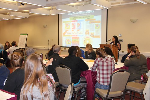

4-H Delegates learn about Team Nutrition resources as nutrition education tools to take back to their schools and communities.
One key strategy in helping schools serve nutritious and appealing meals that students will eat is to simply ask, “What do you need?”
On April 9, USDA Food and Nutrition Service (FNS) asked this simple yet compelling question to nearly 40 4-H delegates at the 2016 National 4-H Conference in Chevy Chase, Md. USDA FNS hosted the roundtable session, “Healthy Eating in Schools: A Dialogue with USDA Food & Nutrition Service,” in an effort to give eager student leaders a chance to share their views on school meals and healthy eating. Participants came from all across the U.S. states and territories, from Nebraska to North Carolina, and as far away as Puerto Rico and a U.S. Air Force base in Japan.
“I was able to have a say in our lunches. I feel that a direct contact discussion, such as today, would be important to hear what students have to say.” – Student, age 15, Connecticut
4-H delegates were asked a series of questions to gauge their thoughts and experiences with school meals. They responded passionately and expressed excitement about incorporating local foods into their school menu and recommended more fresh fruits and vegetables in their cafeterias. Students also shared their breakfast and lunch preferences and offered ideas to increase School Breakfast andSchool Lunch participation in schools. USDA will add the students’ unique responses and perspectives to its growing arsenal of feedback and suggestions from schools, parents, and administrators. We frequently use these recommendations to enhance USDA’s Child Nutrition Programs and develop resources and guidance materials for program operators.
After 30 minutes of thought-provoking roundtable discussions, 4-H delegates took a small break and competed in the “USDA Top Chef School Lunch Challenge.” Delegates were instructed to assemble a nutritious and appealing school lunch tray and menu using a kit of colorful food models from all five food groups. After five minutes of meal planning, students presented their school lunch trays and menus on the “USDA Top Chef” buffet table. Students used forks to vote for their favorites by placing one next to their top choice. The winner with the most forks was an oldie but goodie: spaghetti with meatballs. However, we would like to give a shout-out and honorable mention to a very creative menu: “Ir’roast’istible Beef with Local Corn on the Cob, Sweet Nectarine, Whole Wheat Roll, and Legend ‘Dairy’ Milk”.
To further engage students in school meals and nutrition, USDA presented Team Nutrition resourcesas tools to help 4-H delegates improve nutrition in their schools and communities, as well as among their peers. Team Nutrition’s newest hands-on resource kit for summer meal sites was also highlighted as yet another resource 4-H youth can use when engaging in leadership activities in their communities. “It made me realize just how much I could do in my school to help students live a healthier lifestyle and gave me a list of programs and ideas to take back and share with the community.” – Student, age 17, Puerto Rico
This roundtable session gave students the opportunity to learn from each other and opened up their eyes to just how much school meals and school environments vary from location to location. Many participants were excited about some of the school meals promotion activities happening in other schools and expressed interest in trying out those ideas in their own schools and engaging other students in the process. They left the session feeling inspired to make a difference in schools. “Personally, this session has inspired me to work towards starting new programs [about healthy eating] within my local high school.” – Student, age 18, Connecticut
We are excited to see what will transpire next as students bring their tools and ideas back to their school cafeterias. This 4-H youth roundtable session was yet another way USDA is offering technical assistance, listening to school meals program participants, and promoting a healthier school environment. USDA is committed to enhancing our school meal programs and maximizing benefits for meal program participants across the country. We will continue to gather feedback from our hungry and active end-users. Students have a voice, and USDA is listening.
The winning school meals tray and menu: Spaghetti with Meat Balls
Sending American Astronauts to Mars
From #NASA:

We are closer than ever before to sending American astronauts to Mars. But getting to the Red Planet is hard. That's why we make it a priority to reach out to partners across America and around the world. Our Deputy Administrator Dava Newman on the importance of partnerships on the#JourneyToMars: http://go.nasa.gov/1rA31cE

We are closer than ever before to sending American astronauts to Mars. But getting to the Red Planet is hard. That's why we make it a priority to reach out to partners across America and around the world. Our Deputy Administrator Dava Newman on the importance of partnerships on the#JourneyToMars: http://go.nasa.gov/1rA31cE
Glacial Outburst Flood from Vatnajökull in Iceland
From the U.S. Geological Survey (USGS):

Among the many adjectives for glaciers—spectacular, majestic, awe-inspiring—speed is not usually high on the list. However, glaciers are not always as slow as they look:http://on.doi.gov/1YTBkpk
Image shows a glacial outburst flood from Vatnajökull in Iceland. Credit: Oddur Sigurðsson, Iceland Meteorological Office. #USGS #Science#glaciers
Wednesday is Prime Rib Day
Wednesday is Prime Rib Day: The prime rib, also known as the standing rib roast, is a choice beef cut from one of the eight prime cuts of beef.
Fast food restaurant helps fulfill wish for dying woman
Fast food restaurant helps fulfill wish for dying woman: After her mom made the request for her last meal, Jackie Traxler called three separate Burger King locations at 4 a.m., determined to get a Whopper.
Rocky Mount Fire, Virginia
From Landsat:


Rocky Mount Fire, Virginia
On April 20, 2016, the Operational Land Imager (OLI) on the Landsat 8 satellite acquired these images of the Rocky Mount fire in Virginia. The wildfire burned in Shenandoah National Park, closing sections of trails and a portion Skyline Drive—the park’s main paved thoroughfare. On this day, smoke blew northwest toward Harrisonburg.
The lower image shows a closer view of the fire front. Red areas are where the fire was actively burning; dark brown areas to the east are scars on newly burned land.
The fire was first reported on April 16, and the cause is under investigation. As of midday on April 22, the fire had burned 7,935 acres and was 40 percent contained.
NASA Earth Observatory images by Joshua Stevens, using Landsat data from the U.S. Geological Survey. Caption by Kathryn Hansen.
Read More at:
http://
and/or
http://
#Landsat
April 26-28, 2011 Tornadoes
From the U.S. National Weather Service (NWS):

Today we remember one of the largest, deadliest, and most destructive tornado outbreaks in U.S. history. This outbreak produced 207 tornadoes, four of which were rated EF-5, in nine states. There were 319 fatalities and 2,839 people injured. Read more about this outbreak:http://www.nws.noaa.gov/

Today we remember one of the largest, deadliest, and most destructive tornado outbreaks in U.S. history. This outbreak produced 207 tornadoes, four of which were rated EF-5, in nine states. There were 319 fatalities and 2,839 people injured. Read more about this outbreak:http://www.nws.noaa.gov/
No Tropical Cyclones Today!
April 27, 2016
From NASA's Hurricane Web Page:

There are no tropical cyclones or areas suspect for development, anywhere in the world today. This is a composite image of the world from NASA's Terra satellite with images stitched together from April 26 and 27. Credit: #NASA #NASATerra #Earthrightnow
From NASA's Hurricane Web Page:

There are no tropical cyclones or areas suspect for development, anywhere in the world today. This is a composite image of the world from NASA's Terra satellite with images stitched together from April 26 and 27. Credit: #NASA #NASATerra #Earthrightnow
She survived her first driving-while-texting accident – but not her second
OAKDALE, CALIF.
http://www.miamiherald.com/news/nation-world/national/article71022122.html#fmp
Oakdale teen Amanda Clark’s phone conversation came to an abrupt end when her Chevrolet Trailblazer rolled three times before landing on its roof. She’d run a stop sign and was broadsided by another driver. Metal caved in around her but the roof stayed intact and she survived with just scrapes and bruises.
http://www.miamiherald.com/news/nation-world/national/article71022122.html#fmp
Tuesday, April 26, 2016
Grand Teton National Park
April 26, 2016
From the U.S. Department of the Interior:

One of the most photogenic places on earth, Grand Teton National Park in Wyoming never disappoints. With a total height of over 13,000 feet, the mountains tower 7,000 feet over the Snake River Valley. Created by geologic forces over the course of 10 million years, don’t you think it’s about time you saw it for yourself? Photo by Michel Hersen (www.sharetheexperience.org)
An Infrared Look at the U.S.
From NASA's Hurricane Web Page:

An Infrared Look at the U.S.
The National Weather Service is expecting a Severe Weather Outbreak Likely Over Portions Of The Central And Southern Plains
A significant severe weather outbreak is expected later this afternoon into tonight over a large portion of the Central and Southern Plains. The potential exists for long track tornadoes, very large hail, destructive straight line winds, and heavy rainfall. By Wednesday, the severe weather threat shifts east to the Mid South and South Central U.S.
This infrared image from the AIRS instrument aboard NASA's Aqua satellite shows very cold cloud top temperatures in Wyoming and western Nebraska. AIRS showed that cloud tops were as cold as -63F/-53C (purple), indicating powerful uplift. Those storms are moving east today.
A Sudden Color Change on Lake Kivu
From NASA Earth:

A Sudden Color Change on Lake Kivu
In April 2016, the waters of Lake Kivu in central Africa changed color unexpectedly. The blue freshwater lake turned milky in color, as viewed from boats and from space. Such a sudden change would attract the attention of people anywhere in the world, but it commands particular attention when you live on the edge of a lake known to harbor potentially deadly stores of gas.
Lake Kivu is one of Africa’s “great lakes,” and it straddles the border between Rwanda and the Democratic Republic of the Congo. The lake is a source of drinking water and fish, as well as a transportation route, ;for nearly two million people.
But it is also connected to the volcanic plumbing of the East African Rift. There are vast stores of dissolved methane and carbon dioxide in the depths of Lake Kivu, which is a concern because other lakes in Africa have been known to abruptly discharge gas and suffocate people nearby. For this reason, scientists have been monitoring water and volcanic conditions through the Lake Kivu Monitoring Program (LKMP), and engineers have been developing a platform for extracting those gases to produce energy and to reduce the hazard.
Augusta Umutoni, head of the LKMP, noted that her research team detected some seismic and volcanic activity in April, which initially heightened concern about the lake. But it turns out that this month’s color change was actually much less ominous. Lake Kivu is going through a “whiting event” similar to those that occasionally happen on the Great Lakes of North America and several large lake (such as Geneva) in Europe. The Moderate Resolution Imaging Spectroradiometer (MODIS) instruments on NASA’s Terra and Aqua satellites peeked through the clouds to acquire three natural-color images of the lake whiting event on April 10, 18, and 20, 2016.
Whiting occurs when air and water temperatures rise, as does the pH level near the surface, in a lake that is rich in calcium carbonate. As the temperature and pH rise, the carbonates start to precipitate out of the water as calcite particles that have a white or gray color. Phytoplankton blooms can also lead to whiting-like effects.
“We don’t yet know for sure what caused this particular whiting event at Lake Kivu,” said Martin Schmid of the Swiss Federal Institute of Aquatic Science and Technology. “It is certainly unusually strong, but there have been similar weaker events before. It can be caused by a phytoplankton bloom, by high surface water temperatures, or by a combination of both.”
Robert Hecky of the University of Minnesota-Duluth added that mixing of the surface waters with lower layers can bring up more calcium and nutrients from the depths, promoting blooms or whiting events. “The mixing is an annual event, but the intensity of response of carbonate precipitation varies,” he said. “East African lakes do respond to El Niño events, and the current El Niño may also have had an affect on the physical processes in the lake.”
http://go.nasa.gov/1WnZ4my
Spring Thunderstorms
From Cyprus Creek National Wildlife Refuge:

Spring thunderstorms rolled on through the Refuge on April 21st.
Photo by Tara Gracer/USFWS — at Hickory Bottoms Access.

Spring thunderstorms rolled on through the Refuge on April 21st.
Photo by Tara Gracer/USFWS — at Hickory Bottoms Access.
From Jupiter to Mars
From #NASA:

From Jupiter to Mars, here are a few things to know about our solar system this week:http://nasa.tumblr.com/

From Jupiter to Mars, here are a few things to know about our solar system this week:http://nasa.tumblr.com/
This Day in Fort Scott History
From Fort Scott National Historic Site, National Park Service:

This Day in Fort Scott History
April 26, 1858
"I have seen Gen Eldridge, and he informs me that he has in his possession 40 Halls Carbines which we can have by paying $30 dollars charges. If you have an opportunity to have them brought down I will stand to you responsible for the charges upon delivery of the guns to me.... Come right to my house - procure a guide from the Little Osage. Yours etc Wm R Griffith" At the height of the fight to determine the destiny of Kansas Territory, abolitionists like Griffith held steadfast to their cause. Griffith became the first Kansas State Superintendent of Public Instruction in 1861 before his untimely death in February 1862.
Photo of William Griffith
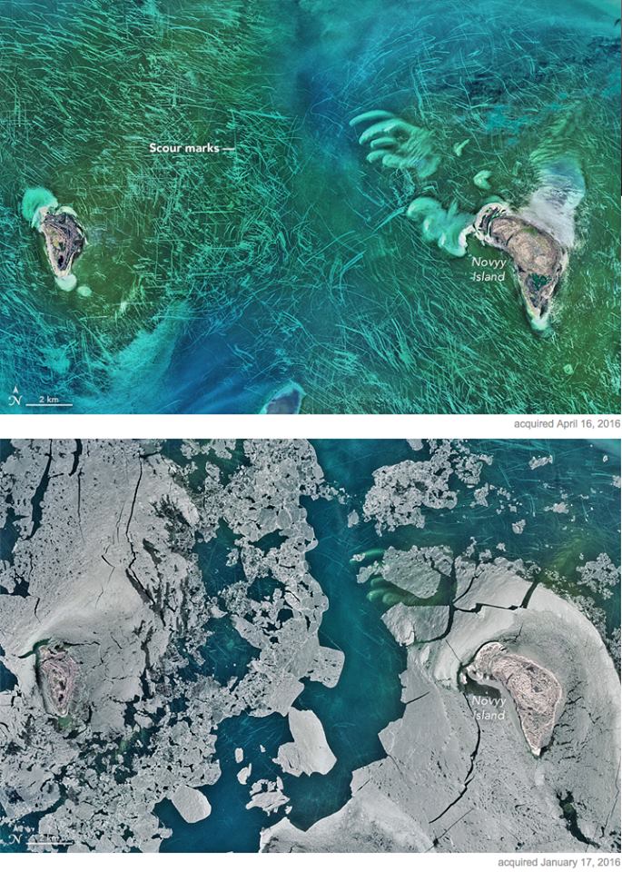
Ice Scours the North Caspian Sea
From Landsat:

Ice Scours the North Caspian Sea
In early April 2016, ocean scientist Norman Kuring of NASA’s Goddard Space Flight Center found a puzzling image that showed lines crisscrossing the North Caspian Sea. On its own, the image was strikingly beautiful. Shallow waters surrounding the Tyuleniy Archipelago allow you to see the dark green vegetation on the sea bottom. But the question remained: what caused those lines?
The Operational Land Imager (OLI) on the Landsat 8 satellite acquired these natural-color images of the curious scour marks. The first image was acquired on April 16, 2016. The second was acquired on January 17, 2016, when parts of the sea were still frozen. The downloadable large image shows a wider view of the Caspian Sea around the Tyuleniy Archipelago on April 16.
The dark green areas—possibly sea grass or benthic algae—and the lines are features of the sea bottom. “You can tell this by the fact that marks laid down in January have not moved by April,” Kuring said. “If those were water features, they would not persist through one tidal cycle.”
It’s possible that some of the marks have a human origin. Similar lines show up in the world’s oceans because of trawling. But the scientific literature and the January satellite image suggest that a majority of the marks in the images above were gouged by ice. Turn on the image comparison tool to see the seasonal change. In January, blocks of ice stand at the leading end of many lines, most notably in the northeast corner of the image. By April, ice has melted and only the scour marks persist.
Stanislav Ogorodov, a scientist at Lomonosov Moscow State University who has published research on the phenomenon, agrees: “Undoubtedly, most of these tracks are the result of ice gouging.” Ogorodov notes that this part of the Caspian is very shallow—about 3 meters deep. Ice that forms here in wintertime is usually about 0.5 meters thick, so most of it never touches the seafloor. But the ice tends to be “warm” and thin, which gives rise to relatively weak ice cover that is easily deformed by wind and currents. When pieces of ice are pushed together, some ice is forced upward and downward into so-called “hummocks.” The keels of hummocks, frozen into the ice fields, can reach the seafloor and scour the bed as the ice moves.
NASA images by Norman Kuring, NASA’s Ocean Color web. Caption by Kathryn Hansen.
Read More at:
http://
and/or
http://
#Landsat
Seeing the Sun Rise in the Continental U.S.
From the U.S. Department of the Interior:
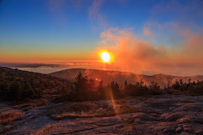
If you want to be the first person to see the sunrise in the continental U.S., you’ll need to take an early hike up Cadillac Mountain in Acadia National Park. As the sun peeks above the horizon and lights the Maine coastline, you’ll be treated to this gorgeous scene. Consider it a daily dose of nature’s love. Photo by National Park Service. — at Acadia National Park.
#Sunrise
Five Years Ago Today
From U.S. National Weather Service (NWS):

Five years ago today, 56 tornadoes touched down in eight different states. There were no fatalities and seven injuries. Read more about this outbreak:
http://www.nws.noaa.gov/

Five years ago today, 56 tornadoes touched down in eight different states. There were no fatalities and seven injuries. Read more about this outbreak:
http://www.nws.noaa.gov/
#safeplaceselfie
From U.S. National Weather Service (NWS):

Do you know where to go when a tornado is headed for your home? http://www.spc.noaa.gov/Show us at #safeplaceselfie & join us for tweet chat this Saturday.

Do you know where to go when a tornado is headed for your home? http://www.spc.noaa.gov/Show us at #safeplaceselfie & join us for tweet chat this Saturday.
Image from NOAA's DSCOVR satellite
April 26, 2016
From NASA's Hurricane Web Page:

There are no tropical cyclones or areas suspect for development anywhere in the world today. Here's a look at the world from 1 million miles away, courtesy of NASA's EPIC camera that flies aboard NOAA's DSCOVR satellite. This image was taken on April 26 and shows the Pacific Ocean.
Subscribe to:
Posts (Atom)