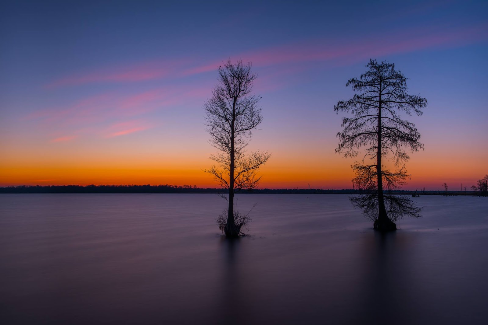
Virtually unchanged except by the forces of nature,Gates of the Arctic National Park and Preserve in Alaska is as wild as it is vast. Through endless summer days and winter nights colored by the Northern Lights, visitors travel by rivers and mountains yet to be named. With no roads, no trails and very few people, it’s the perfect place for those seeking solitude and natural beauty. Photo by Carl Johnson, National Park Service. — at Gates of the Arctic National Park and Preserve.
Tomorrow is Presidents' Day!Normally the Harry Truman Home is closed on Monday's during the winter season. However, since this Monday is Presidents' Day we will be providing guided tours on the holiday! Tour tickets may be purchased at our visitor center at 223 N. Main Street, just north of the Independence Town Square. Tours are limited to eight people at a time and are available first-come, first-served.
Icy Lake ErieThe unusually cold winter in the Upper Midwest has led to a notable buildup of ice on the Great Lakes.On February 14, 2018, the Moderate Resolution Imaging Spectroradiometer (MODIS) on NASA’s Aqua satellite acquired data for these false-color images of North America’s Great Lakes. The images were made from a combination of infrared and visible light (MODIS bands 7-2-1) in order to better differentiate between snow and ice (teal) and clouds (white). Open water appears black, though some of the dark areas likely have a layer of clear ice (without snow cover on it).
When these data were acquired, 57.9 percent of the surfaces of the Great Lakes were covered with ice, according to NOAA’s Great Lakes Environmental Research Laboratory. On the same date last year, total ice cover was 9.7 percent. Lake Erie was the iciest of the five lakes, with 93.3 percent iced over.
Lake Erie is slightly larger in surface area than Lake Ontario (the smallest of the five Great Lakes), but Erie is relatively shallow and contains less than one-third of the volume of water found in Lake Ontario. Lake Erie is generally the first to freeze in winter and the first to thaw in spring.
All of the ice poses challenges for shipping. In January 2018, the U.S. Coast Guard sent an icebreaker to free five ships trapped in ice in the Straits of Mackinac. However, it is a boon for fisherman. Outdoor shops that cater to ice fisherman on Lake Erie have seen a spike in equipment supplies, according to AccuWeather.
https://go.nasa.gov/2ExzxH5
The #weekend is coming to a close, but we still have time for some sunshine. #SundaySunshine to be exact. Today, enjoy this view of the Ruedi Reservoir,15 miles east of Basalt, #Colorado. Why not plan a trip and see it for yourself? Visitgo.usa.gov/xnAFt today. #Winter
The northern leopard frog is one of the most common amphibians you can find in prairie wetlands. Most will spend the winter hibernating away from the cold on the bottom of lakes and wetlands. Donna Oglesby/USFWS
#animal #amphibian #frog #nature #wildlife #USFWS
Jupiter’s vibrant bands of light belts and dark regions appear primed for their closeup  📸 during NASA's Juno Mission to Jupiter spacecraft’s 10th flyby on Feb. 7. The science behind this beautiful image will help us understand the planet beneath those lush, swirling clouds:http://go.nasa.gov/2BMrdBN
Located in southeastern Virginia and northeastern North Carolina, Great Dismal Swamp National Wildlife Refuge is anything but dismal. With more than 111,200 acres of seasonally flooded wetland forest and the 3,100-acre Lake Drummond at its center, the refuge contains some of the most important wildlife habitat in the mid-Atlantic region. In the winter, the lake provides a resting place for thousands of migratory birds including Tundra Swans and Snow Geese. In the summer, it’s home to Great Blue Herons and Great Egrets. It’s also an amazing place to witness the start of a new day. Photo courtesy of Tom Hamilton. — with Tom Hamilton Photography at Great Dismal Swamp National Wildlife Refuge.
#nature #wildlife #habitat
National Geospatial Program Garners Elevation Award: The USGS 3D Elevation Program (3DEP) team has been selected as the recipient of the 2018 “LIDAR Leader Award”, presented at the recent International LIDAR Mapping Forum in Denver. The “Outstanding Enterprise Achievement in LIDAR” award recognizes exceptional achievements in the area of service, project management or product development within the realm of geospatial lidar technology. https://go.usa.gov/xnst9
Early detection and rapid response help keep invasive European Green Crab at bay in Padilla Bay#NERR https://go.usa.gov/xnfpR #EstuaryLove
Great Gray Owl: You can find these owls perched above, listening and watching for prey. They love to feast on small rodents such as voles and shrews. (Photo: USFWS/Wild North Photography)#WildlifeWednesday #WildWednesday #owls
Snowshoe hare are well equipped for cold and snowy winters. Their large feet allow them to run across soft snow without sinking, sometimes reaching speeds of up to 30 mph!Photo: Snowshoe hare by Tim Rains/NPS.
#animal #mammal #hare #nature #wildlife #snow #winter
V
.Harmful algal blooms and their toxins can kill #wildlife and pose health risks for humans#Science to the rescue! A new #USGS water-quality monitoring program can aid restoration of the Great Lakes. The goal of the program is to provide scientists and managers with the best available data to help evaluate the health of #GreatLakes ecosystems and improve #water quality for recreation and commercial fishing.
Read all about the new program athttps://go.usa.gov/xnsPf.
Algal bloom photo credit: Jennifer Graham, USGS
#waterquality #GreatLakesRestorationInitiative
V
FREE EVENT: Come view sandhill cranes at the Merced National Wildlife Refuge: February 10th at 4:30 p.m.Time is running out! The wintering sandhill cranes will be in the San Joaquin Valley for only another 4 to 6 weeks before they migrate north to their summer breeding grounds in Alaska.Many of you are familiar with the corn croplands along the Merced NWR auto tour route and the wildlife spectacle that is created by the annual mowing of the corn. The Refuge will begin mowing the corn next week -- mowing makes it accessible for the cranes and geese to eat. The corn will be mowed in stages throughout the month, creating terrific viewing opportunities over the next four weeks.
Join us at the Merced NWR on Saturday, February 10th, at 4:30 p.m. to visit with refuge staff, ask questions, and learn about the sandhill cranes and other winter visitors. We will learn about the cranes’ life history and about the amazing adaptations they and other migratory birds have, that support their unique lifestyle.
Witness the spectacle of the evening fly-in as the cranes return from their day of foraging to roost in the refuge wetlands overnight.
Meet at the Merced NWR main entrance information kiosk off Sandy Mush road at 4:30 p.m. From there we will caravan along the tour route in attendees' vehicles to a spot to view the cranes. Be sure to bring binoculars, spotting scopes, field guides, water, hats, sunscreen, etc. There is no charge for this event and need to sign up – just join us!
Call the Refuge Complex at 209/826-3508 for more information, driving directions, or to ask questions. The Merced NWR is located at 7430 W. Sandy Mush Rd., Merced, CA, 95341. Driving directions can also be found on the refuge website:www.fws.gov/refuge/merced
We hope to see you there!
Photo courtesy of Lee Eastman, USFWS
We often forget how different things were in the early 19th century, compared with today. For example, let’s think about the largest city in the western frontier – what was known in 1800 as the Indiana Territory. Specifically, we’ll focus on what we know today as the state of Illinois. If asked “What was the largest city at the turn of the century,” most people would instinctively answer, “Chicago.”
It’s the obvious, but incorrect answer. In 1803, Chicago was nothing more than a small U.S. fort – Fort Dearborn, situated where the main stem of the Chicago River flows out of Lake Michigan.
The honor of largest city in the Illinois area at the time of Lewis and Clark goes to Cahokia with 719 citizens. Located on the east side of the Mississippi River, the city was about four miles downstream from St. Louis. Second place goes to Kaskaskia which had approximately 470 residents.
This photo is of the Church of the Holy Family, built in 1799 in Cahokia. The church was formed in 1699 and is today one of the oldest Catholic congregations in the U.S.
We’ll look into both cities in upcoming posts.
People who are not familiar with southwestern plants often mistake the fruit of a cane cholla for flowers.From a distance the bright yellow fruit can look like blossoms, but the real flowers of the cholla are pink.One other lesson to be learned about cholla-- view at a safe distance. The plant can't throw needles any more than a porcupine can, but tiny, thin spines detach at the lightest contact and are incredibly hard to remove.
The antidote? Gorilla tape! Place a piece across the area with needles and give a good yank to get the tape off. The hair-fine (and really painful) spines usually stick to the tape and come out.
Better yet. View from a safe distance and don't test the theory.
Common red polls are occasionally spotted moving through the refuge during the winter months. These talkative, energetic birds often travel in flocks and are frequently spotted at backyard feeders.Photo: Common redpoll by Courtney Celley/USFWS.
#animal #bird #nature #wildlife #USFWS
Northern elephant seals enjoy a diet rich with fish and squid - but these prey also expose the seals to mercury. How does this mercury respond to changes in the animal's body? To find out, current USGS wildlife biologist Sarah Peterson started working with USGS lead scientist Josh Ackerman as part of her graduate studies at UC Santa Cruz. Peterson and Ackerman found that the concentration of mercury in the blood of northern elephant seals increased when they lost mass during the two seasons in which they haul out on land and fast. Likewise, the concentration of mercury in the animals' blood decreased when they gained mass while feeding at sea.
The study findings could help wildlife managers effectively monitor the risk posed to wildlife exposed to contaminants in their environment.
Photo Caption: Picture of a male northern elephant seal. Twice a year, these animals haul out on sandy beaches along the California coast for the molting and breeding seasons. Male and female elephant seals do not eat while on land (a stretch of weeks to months). Often, they lose more than a third of their mass before returning to sea, but they make up for it with foraging trips that last between 2.5 to 7 months! Photo credit: Sarah Peterson/USGS.
"Looking Back"Sometimes we’re so focused on climbing the hill that we forget to stop, pause, and take a moment to look back. But taking stock and looking back is so often what drives us to keep moving forward.NPS Photo/Melissa Sladek
[Ski tracks wind through powdery snow. Trees line the snow-laden road; mountains and clouds show in the distance.]
#snow #crosscountryskiing #winter #glaciernps#GlacierNationalPark
Mention the word "lamprey" to most Minnesota fisherman and they will tend to think of the invasive sea lamprey that had wreaked havoc with native fish populations in the Great Lakes. However, there is a native lamprey found in Voyageurs National Park: the silver lamprey. Silver lampreys are parasitic fish that commonly feed on the flesh of northern pike, lake sturgeon, and white suckers. Unlike the invasive sea lampreys, the native ones have evolved with and live in balance with other native fish in the Rainy Lake Basin. #WildlifeWednesday(Image Description: A lamprey fish rests on a white surface.)
Wolves prey primarily on large ungulates such as moose and white-tailed deer, but they also prey on American beaver. Moose populations have been declining in northeastern Minnesota in recent years but remain stable in Voyageurs National Park(VOYA) at a low density. Steve Windels, wildlife biologist at VOYA, is investigating whether wolf predation on moose is alleviated by the abundance of alternative prey like beaver and deer.
To better understand wolf predation on these animals, in 2016, Windels enlisted the help of interns Austin Homkes and Tom Gable, both graduate students at the time at Northern Michigan University. The team captured wolves using foothold traps and fit them with a global positioning system (GPS) telemetry collars (pictured here). They documented kill site characteristics and wolf movements before, during, and after the kills using the high intensity (locations every 20 min) GPS collar data. From April to November of 2016, they documented 96 total kill sites. The researchers conducted white-tailed deer pellet counts to estimate the relative abundance of deer in the area, and conducted aerial surveys to estimate abundance of beaver and moose populations. This information will contribute to an understanding of wolf predation rates on these alternative prey species and will also help managers understand the bigger picture of the effects of wolves on at-risk moose populations.
Photo by Tom Gable
#ParkScience #VoyageursNationalPark #wolves
Yesterday's storm blanketed the dunes with fresh snow, making for good sledding and skiing conditions this week! Check the park webcam for current snow conditions:https://www.nps.gov/grsa/learn/photosmultimedia/webcams.htmPhoto: NPS/Patrick Myers#GreatSandDunes #Dunes #Winter #Snow #Skiing#Sledding
Did you know that… baby porcupines are called porcupettes? They are born with soft quills that harden within a few hours. Photo by VIP Matt Walters (hl) #DYK #DidYouKnow #animals #wildlife#mammals #PetrifiedForest #NPS