September 15, 2015
From the U.S. Department of the Interior:
Just before it flows past Washington, DC, the Potomac River builds up speed and force as it falls over a series of steep, jagged rocks and rushes through a narrow gorge. Great Falls Park offers tremendous views of this powerful, natural spectacle. Hikers enjoy several trails along the river and sometimes gasp at expert kayakers who brave the falls. This #sunrise picture was taken on the Virginia side of the river. Photo by Yin Lau. (www.sharetheexperience.org) — at Great Falls Park.
Current events involving politics, political office holders, political candidates, world events, local events, crime and other public affairs issues are discussed. Business news items as well as science and technology issues may appear.
Search This Blog
Tuesday, September 15, 2015
Canyon or Ridge?
From NASA's Earth Observatory:
Canyon or Ridge?
On August 29, 2015, NASA astronaut Kjell Lindgren tweeted this photograph of a canyon from the International Space Station. "Flying over Arizona. Crazy how the shadows make this canyon look like a ridge!" he noted. Lindgren was noticing an optical illusion called relief inversion. The effect happens because most of us expect an image to be lit from the top left corner. When the sunlight comes from another angle (especially from the lower edge), the shadows fall in ways we don’t expect and our brains turn valleys into mountains to compensate. The problem is usually resolved by rotating the image so the light appears to come from the top of the image. In this case, does that work for you?
Read more about relief inversion at
http://go.nasa.gov/1LekxKa
Read a blog post about relief inversion at
http://go.nasa.gov/1LekApd
Read more about relief inversion from Shaded Relief at
http://go.nasa.gov/1Leky0u
See Lindgren's original tweet at
http://go.nasa.gov/1Leky0w
Canyon or Ridge?
On August 29, 2015, NASA astronaut Kjell Lindgren tweeted this photograph of a canyon from the International Space Station. "Flying over Arizona. Crazy how the shadows make this canyon look like a ridge!" he noted. Lindgren was noticing an optical illusion called relief inversion. The effect happens because most of us expect an image to be lit from the top left corner. When the sunlight comes from another angle (especially from the lower edge), the shadows fall in ways we don’t expect and our brains turn valleys into mountains to compensate. The problem is usually resolved by rotating the image so the light appears to come from the top of the image. In this case, does that work for you?
Read more about relief inversion at
http://go.nasa.gov/1LekxKa
Read a blog post about relief inversion at
http://go.nasa.gov/1LekApd
Read more about relief inversion from Shaded Relief at
http://go.nasa.gov/1Leky0u
See Lindgren's original tweet at
http://go.nasa.gov/1Leky0w
Real Playa
From the U.S. Geological Survey (USGS):
Real Playa — No, no, this isn't the name of the next rap hit from Drake, nor is it pronounced the same way, but for us it's an original playa. This playa photo is from Surprise Valley in California and, in the distance, you can see the Warner Mountain Range.
So what's a playa? A playa is a dry, vegetation-free, flat area at the lowest part of an undrained desert basin. It is a location where ephemeral lakes form during wet periods, and is underlain by stratified clay, silt, and sand, and commonly, soluble salts. Playas occur in intermountain basins throughout the arid southwestern United States. Although playas may appear as featureless plains, they are rich in features and characteristics that can reveal information about climates, past and present. Many playas in the Mojave region were the location of lakes and marshes during the last glacial period. These perennial water bodies completely dried up about 8,000 years ago. Today they flood only after seasonal storms provide flash flood waters, or in some cases, springs discharge large quantities of groundwater onto the playa. Photo credit: Jonathan Glen, USGS.
#USGS #science #playa #desert #California#geography #water
Real Playa — No, no, this isn't the name of the next rap hit from Drake, nor is it pronounced the same way, but for us it's an original playa. This playa photo is from Surprise Valley in California and, in the distance, you can see the Warner Mountain Range.
So what's a playa? A playa is a dry, vegetation-free, flat area at the lowest part of an undrained desert basin. It is a location where ephemeral lakes form during wet periods, and is underlain by stratified clay, silt, and sand, and commonly, soluble salts. Playas occur in intermountain basins throughout the arid southwestern United States. Although playas may appear as featureless plains, they are rich in features and characteristics that can reveal information about climates, past and present. Many playas in the Mojave region were the location of lakes and marshes during the last glacial period. These perennial water bodies completely dried up about 8,000 years ago. Today they flood only after seasonal storms provide flash flood waters, or in some cases, springs discharge large quantities of groundwater onto the playa. Photo credit: Jonathan Glen, USGS.
#USGS #science #playa #desert #California#geography #water
Monday, September 14, 2015
Update on The Rough Fire in California
From #NASA:
The Rough Fire in California continues to burn and is currently the largest active fire in the state. There are 3,229 personnel assigned to the fire, and containment remains at 40%. Details: http://go.nasa.gov/1URkzIz#EarthRightNow
Exploring The Loch
From the U.S. Department of the Interior:
Exploring The Loch -- a beautiful alpine lake in Rocky Mountain National Park’s Glacier Gorge -- is definitely worth the trip. Erik Stensland took this stunning photo from the area on the first morning the park opened following the a historic flood to the area in 2013. Of the capturing the photo, he says, “The clouds parted just as the sun rose, lighting the top of a rock formation called The Cathedral.” Photo courtesy of Erik Stensland. — with Erik Stensland Fine Art Photography at Rocky Mountain National Park.
The Right Acres in the Right Place at the Right Time - Coastal Headwaters Forest
From the #USDA:
Posted by Ciji Taylor, Natural Resources Conservation Service, on September 14, 2015 at 3:30 PM

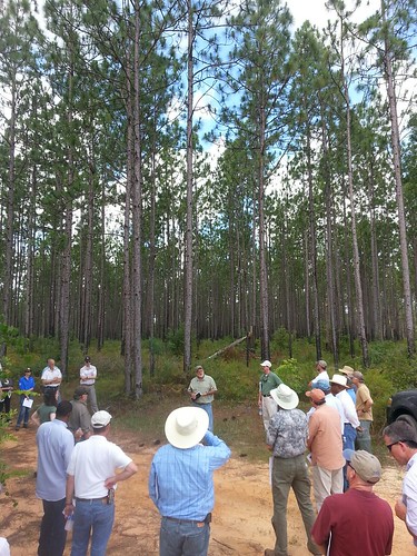
A group recently toured a RCPP project area in the Coastal Headwaters Forest. Photo by The Conservation Fund.
The Conservation Fund helps conserve and restore our American landscape, including wild areas, popular parks, working forests and more. A partner in conservation, The Conservation Fund received a $5 million grant from the Regional Conservation Partnership Program (RCPP) for the Coastal Headwaters Forest project. RCPP, administered by USDA’s Natural Resources Conservation Service, is a new program created by the U.S. Congress through the enactment of the 2014 Farm Bill. Its goal is to provide landscape-scale conservation assistance and significantly leverage partnerships and non-federal funding. The grants will be used to protect a portion of the 205,000-acre Coastal Headwaters Forest under a conservation easement during the first phase of this multi-year project. – Ciji Taylor, NRCS
Guest blog written by Ann Simonelli of The Conservation Fund
Unprecedented in size and scope, the 205,000-acre Coastal Headwaters Forest project is the largest single longleaf pine protection and restoration effort ever proposed on private lands.
Located in the Gulf Coastal Plain in western Florida and southwestern Alabama, the project will conserve and restore longleaf pine habitat, protect water quality and quantity, improve habitat for endangered and threatened species and create an innovative approach to longleaf pine protection.
This is one of 115 conservation projects currently being funded by the Regional Conservation Partnership Program (RCPP) in all 50 states and the Commonwealth of Puerto Rico. Through RCPP, NRCS and its partners will help producers install conservation practices and maintain conservation activities in selected project areas in the Coastal Headwaters Forest. Through a perpetual conservation easement, these projects will protect approximately 9,000 acres.
“RCPP encourages partners to join in efforts with producers to increase the restoration and sustainable use of soil, water, wildlife and related natural resources on regional or watershed scales,” said Russell Morgan, NRCS state conservationist in Florida.
On a recent tour of forest land enrolled in this RCPP project, NRCS, The Conservation Fund and partners met with the landowner, Resource Management Service (RMS) to discuss working together to protect and restore the forest habitat while maintaining sustainable timber operations.
“We are working to place a conservation easement on the entire property in phases to create and sustain an economically viable and healthy working forest,” explained Jimmy Bullock, senior vice president, forest sustainability for RMS. “This project ensures local communities benefit from the economic and social values of a working forest, and restores and maintains the ecological values for plants and animals inherent to the longleaf ecosystem.”
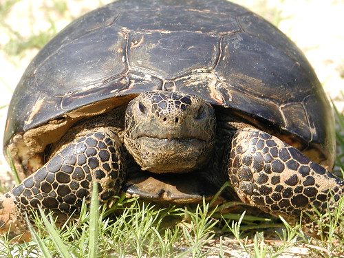
An unexpected guest, a gopher tortoise, joined the tour briefly – and rather slowly – on the way to its burrow. The tortoise, a federally threatened species, lives in dry, sandy uplands like those found on the Coastal Headwaters property. One of the primary causes of the drop in their numbers is loss of habitat, and this project will provide significant protection for the species.
Later in the tour as the group was discussing the forest and the species it supports, a military helicopter was heard flying over, likely from nearby Naval Air Station Whiting Field or Eglin Air Force Base. Maintaining this expansive area as a working forest will provide potential training opportunities and long-term certainty and planning ability for the Department of Defense and its local military installations that have flight paths over the property.
“This project is truly the right acres in the right place at the right time,” said Andrew Schock of The Conservation Fund. “Together we can revive hearty, longleaf pine habitat here and secure its presence and benefits, both ecologically and economically, for generations to come.”

The federally threatened gopher tortoise lives on the dry, sandy habitats found in Coastal Headwaters Forest. Photo by Randy Browning, USFWS.
Related Posts
Arnold Schwarzenegger is the next host of NBC's 'Celebrity Apprentice' - Sep. 14, 2015
Instead of "you're fired," will "Celebrity Apprentice" contestants soon hear "you won't be back?"
Arnold Schwarzenegger is replacing Donald Trump on "The Celebrity Apprentice," NBC's long-running business reality show, the network announced Monday.
Arnold Schwarzenegger is the next host of NBC's 'Celebrity Apprentice' - Sep. 14, 2015
Arnold Schwarzenegger is replacing Donald Trump on "The Celebrity Apprentice," NBC's long-running business reality show, the network announced Monday.
Arnold Schwarzenegger is the next host of NBC's 'Celebrity Apprentice' - Sep. 14, 2015
Subscribe to:
Posts (Atom)